Note: This original article is written for web publishing, based on real Google Earth exploration culture, documented geography, and publicly known satellite-imagery discoveries.
When Google Earth Turns Into the World’s Biggest Treasure Hunt
Some people open Google Earth to check their childhood home. Others use it to plan a vacation, inspect a roof, or prove that their neighbor’s pool is definitely larger than necessary. Then there are the true digital explorersthe ones who zoom into deserts, coastlines, rivers, islands, mines, forts, and suspiciously geometric shapes until the planet starts looking like a giant puzzle box.
One of the most entertaining examples is Will, a geologist known online as geologistsmakethebedrock. Instead of using Google Earth only as a map, he treats it like a scientific scavenger hunt. His finds range from elegant natural landforms to odd human-made structures, from peaceful lagoons to shipwrecks that look like they were placed there by a bored movie director. The result is a reminder that Earth is not just roundit is weird, dramatic, funny, and occasionally shaped like someone lost a bet with a bulldozer.
Google Earth makes this kind of curiosity easy. With satellite imagery, 3D terrain, historical imagery, Street View, and measurement tools, anyone can inspect the planet from a laptop. The magic is not just in finding strange places; it is in asking, “Why does it look like that?” That question turns casual scrolling into geography, geology, history, engineering, and environmental observationall without putting on hiking boots.
30 Fascinating Google Earth Finds Worth Zooming In On
1. A Star Fort in Lille, France
From above, old star forts look like geometry homework completed by a military engineer with flair. The fort in Lille stands out because its angular bastions form a crisp, defensive pattern inside a modern city. It is a perfect example of why historic architecture can be easier to appreciate from space than from the sidewalk.
2. A Private Island Off the Coast of Maine
A small island connected by a gated bridge is the kind of Google Earth find that makes people briefly consider becoming reclusive millionaires. Surrounded by water and overlooking a shipping lane, it has all the ingredients of a daydream: privacy, views, and just enough distance from civilization to avoid unexpected guests.
3. Old-Fashioned Salt Extraction Pits
At first glance, patterned salt pits can resemble an abstract painting or an archaeological dig. In reality, they often reveal a practical human relationship with water, sun, and minerals. Satellite views make these sites especially striking because the repeating pools create colors and textures that look almost designed for a gallery wall.
4. A Sinuous River Creating Oxbow Lakes
Few things are more satisfying on Google Earth than a river that refuses to take the direct route. A meandering river shows erosion and deposition in action. When a loop gets pinched off, it can become an oxbow lake, leaving behind a curved scar that tells the story of where the river used to flow.
5. A Desert Oasis With Animal Tracks
An oasis in the desert looks dramatic from above because everything around it says, “Absolutely not,” while the water says, “Fine, I’ll host the party.” Tracks radiating toward a water source may come from vehicles, livestock, or wild animals, creating a visible record of survival in a dry landscape.
6. A Meteor Crater With a Raised Rim
Impact craters are among the most thrilling Google Earth finds because they look so unmistakably cosmic. A raised rim, circular basin, and sometimes a central peak can reveal the violent moment when an object from space met Earth with extremely poor manners.
7. A Planned Settlement Near Namibe, Angola
Large planned communities can look mysterious when viewed from above, especially if roads and buildings appear carefully arranged but few vehicles are visible. The Namibe-area settlement discussed by online viewers became interesting not because it was impossible to explain, but because it showed how satellite imagery can spark collaborative investigation.
8. Circular Wave Reflections
Water can turn into a physics demonstration when viewed from orbit. Circular wave patterns or reflections may appear like shattered glass, ripples, or rings. The effect depends on light, water texture, wind, and camera angleproof that Earth occasionally enjoys doing special effects for free.
9. Assamakka, Niger, and the March of Sand
In desert communities such as Assamakka, satellite imagery can reveal how wind shapes the land. Dunes, sand sheets, and wind-aligned patterns may show the prevailing direction of sand movement. It is beautiful from above, but on the ground it can mean a constant battle to keep roads, buildings, and wells usable.
10. A Shipwreck on a Desert Coast
Finding a shipwreck in satellite imagery feels like stumbling onto the opening scene of an adventure novel. Dry coastal environments can preserve metal wreckage, and Google Earth’s historical imagery can sometimes show whether a wreck appeared recently or has been sitting there for years, slowly becoming part of the shoreline.
11. A River Cutting Through Ice
In cold regions, rivers carve dark paths through snow and ice, forming shapes that look organic, delicate, and slightly alien. These scenes are useful reminders that rivers are not passive blue lines on a map; they are active systems with energy, temperature, sediment, and seasonal rhythm.
12. New Orleans After Hurricane Katrina
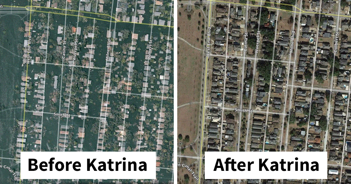
Satellite imagery of New Orleans after Hurricane Katrina remains one of the more sobering examples of what Google Earth can reveal. Flooded neighborhoods, including areas around Lakeview, showed how natural disasters, infrastructure failure, and urban geography can combine in devastating ways. This kind of imagery is not just curious; it is historical evidence.
13. An Octagonal Reservoir in Belgium
Most ponds and reservoirs are roundish, rectangular, or shaped like a spilled drink. An octagonal water structure instantly catches the eye because it looks intentional, engineered, and slightly too tidy. From above, utility infrastructure often becomes unexpectedly elegant.
14. A Park in Pyongyang, North Korea
Satellite views of closed or restricted countries can be especially intriguing because they offer glimpses of places many people cannot easily visit. Parks, monuments, roads, and public squares become readable from above, turning urban planning into a visual language.
15. A Tibetan Plateau Lake in Different Seasons
High-altitude lakes can shift dramatically between summer and winter. Ice cover, snow, exposed shoreline, and water color all change with the season. Google Earth’s time-based imagery makes these contrasts easier to compare, and the Tibetan Plateau provides some of the planet’s most striking examples.
16. A Funny Place Name on the Map
Not every Google Earth discovery needs to be a geological masterpiece. Sometimes the find is simply a town, road, or label with a name that makes people snort coffee through their nose. Maps are serious tools, but they are also full of accidental comedy.
17. The Maeslantkering Storm Surge Barrier
Near Rotterdam, the Maeslantkering is a massive storm surge barrier designed to protect people and infrastructure from North Sea flooding. From above, its enormous gates look like futuristic mechanical arms waiting for bad weather. It is one of those engineering projects that makes humans look surprisingly competent.
18. A Coral Atoll
An atoll is a ring-shaped reef surrounding a lagoon, often connected to the long story of volcanic islands, coral growth, subsidence, and sea level. From Google Earth, atolls look almost unreal: turquoise circles floating in deep blue water, as if the ocean decided to doodle.
19. A Volcano Rising From the South Pacific
A volcanic island or crater emerging from the sea is a dramatic reminder that Earth is still under construction. One viewer identified a South Pacific crater-like feature as Molokini off Maui, a crescent-shaped volcanic islet known for clear water and marine life.
20. A Place Name That Deserves a Double Take
Some map discoveries are funny because the land itself is strange. Others are funny because humans named things before search engines existed. Google Earth has a way of turning obscure place names into international jokes, usually with no warning and no mercy.
21. The Zambezi River Below Victoria Falls
Downstream from Victoria Falls, the Zambezi River follows a dramatic zigzag path through gorges. From above, it looks less like a river and more like a lightning bolt carved into rock. This is exactly the kind of view that makes satellite imagery so powerful: the shape explains the force.
22. A Saw-Tooth Beach Pattern
Beach patterns can look like zippers, teeth, or carefully folded fabric. These shapes often relate to waves, currents, sediment movement, and coastal engineering. To the casual viewer, they are simply pleasingly weird. To coastal scientists, they are clues.
23. The Trinity Test Site in New Mexico
The first atomic bomb test took place at Trinity Site in New Mexico on July 16, 1945. From above, historic test areas and desert markings can look quiet, but their meaning is enormous. Google Earth can turn a remote patch of desert into a doorway into one of the most consequential events of the 20th century.
24. The Shadow of a Mountain
Sometimes the most dramatic thing in a satellite image is not the object itself but its shadow. A mountain shadow can stretch across valleys like a dark cloak, exaggerating relief and creating shapes that look mythical. Earth clearly understands lighting.
25. A Glacier Flowing Into a Lake
Glaciers are slow, but satellite imagery lets us see their movement as part of a larger landscape. A glacier pushing into a lake may create ice dams, color changes, meltwater channels, and level differences. It is frozen water behaving like a bulldozer in slow motion.
26. A Coal-Fired Power Plant Seen From Above
Industrial sites can be visually striking even when they raise environmental concerns. Cooling ponds, smoke plumes, ash areas, conveyor belts, and geometric plant layouts become clear in satellite view. Google Earth does not just show natural beauty; it also shows the footprint of energy demand.
27. Logging Roads Revealed by Vegetation
Dark green lines through a forest may look mysterious until historical imagery reveals old logging roads. Disturbed soil, regrowth, and different plant communities can make abandoned access routes more visible than the surrounding land. The forest remembers, and Google Earth takes notes.
28. A Bluff That Looks Like an Inverted Pyramid
Optical illusions are common in satellite imagery. A coastal bluff, quarry, or eroded landform can look like a pyramid, a crater, or the headquarters of a villain with excellent landscaping. Shadows and perspective can fool the brain faster than a magician with a geography degree.
29. A Map Label That Became the Joke
One of the joys of digital exploration is that humor can hide in plain sight. A funny label, unexpected town name, or awkwardly shaped feature may not be scientifically important, but it keeps the exploration human. Not every discovery needs a peer-reviewed paper; some just need a screenshot and a laugh.
30. More Abandoned Ships Near Tombua, Angola
Ships near Tombua, Angola, caught attention because they seemed to appear in later imagery and may have been intentionally abandoned. Whether caused by economics, storms, salvage decisions, or coastal conditions, abandoned vessels are haunting from above. They look like punctuation marks at the edge of the sea.
Why These Google Earth Finds Are So Addictive
The best Google Earth finds work because they sit between mystery and explanation. A star fort is not mysterious once you understand military design, but it still looks fantastic. An oxbow lake is not magic, but the moment you see the river preparing to cut itself off, the landscape feels alive. A storm surge barrier is practical engineering, yet from above it resembles science fiction.
This is also why Google Earth has become a favorite tool for teachers, geologists, archaeologists, travelers, urban planners, journalists, and curious people with excellent procrastination skills. It compresses distance. You can compare New Orleans flooding, desert dunes in Niger, coral reefs, shipwrecks, mountain shadows, ports, and ancient-looking structures without buying a plane ticket or explaining to airport security why you packed three notebooks and a suspicious enthusiasm for drainage patterns.
The important lesson is to avoid jumping straight from “weird shape” to “aliens,” “secret base,” or “ancient lost civilization.” Many strange sights have ordinary explanations: erosion, mining, agriculture, military history, coastal currents, seasonal ice, or image stitching. But ordinary does not mean boring. In fact, the real explanation is often better because it connects the image to actual Earth processes.
Experience: What It Feels Like to Hunt for Interesting Things on Google Earth
A good Google Earth session usually begins with one innocent search and ends 90 minutes later in a remote desert, staring at a suspicious rectangle and wondering whether dinner can be postponed for “important research.” The experience is part travel, part detective work, and part staring contest with the planet. You zoom in, zoom out, rotate, tilt, switch years, measure a feature, compare shadows, and then realize you have become emotionally invested in a sandbar.
The best way to explore is to follow patterns. Coastlines are great because they reveal shipwrecks, ports, deltas, reefs, barrier islands, and longshore transport. Rivers are even better because they draw their own history across the land. A meander loop, abandoned channel, or delta fan can show decadesor centuriesof movement. Deserts are another favorite because nothing hides very well. Tracks, dunes, mines, settlements, dry riverbeds, and geometric infrastructure stand out sharply against sand and rock.
Historical imagery adds another layer of fun. If a shipwreck appears in one year but not an earlier year, you suddenly have a timeline. If a neighborhood changes after a hurricane, a wildfire, or rapid construction, the map becomes a visual archive. This is where Google Earth stops being a toy and becomes a powerful storytelling tool. It helps users understand change, not just location.
Another useful habit is to ask three questions: Is this natural or human-made? Has it changed over time? What process could create this shape? Straight lines often suggest roads, canals, walls, fields, runways, or pipelines. Curves may point to rivers, dunes, reefs, shorelines, or craters. Repeating patterns can indicate agriculture, salt ponds, mining, fish farms, housing projects, or military layouts. Shadows can reveal height, while color can suggest water depth, vegetation, minerals, sediment, pollution, or seasonal change.
Still, the most enjoyable part is the emotional swing. One moment you feel like a world-class explorer discovering a lost civilization. Five minutes later, you learn it is a wastewater treatment plant. Humbling? Absolutely. Entertaining? Also yes. Google Earth rewards curiosity, but it also teaches caution. The planet has many mysteries, but it also has many drainage ditches with dramatic lighting.
That is why Will’s finds are so appealing. They remind us that wonder does not require a spaceship, a research grant, or a dramatic hat. Sometimes all it takes is a map, patience, and the willingness to say, “Hold on, what on Earth is that?” Then you zoom in, learn something, laugh a little, and maybe discover that geology really does rock.
Conclusion
Google Earth turns ordinary curiosity into a global adventure. The 30 finds above show how much can be discovered by looking carefully: forts hidden in cities, rivers writing their own history, deserts swallowing towns, reefs forming rings in the sea, storm barriers protecting millions, and abandoned ships telling quiet stories from the coast. Some finds are beautiful, some are funny, and some are deeply serious. Together, they prove that our planet is packed with patterns waiting to be noticed.
For anyone who wants to try it, start simple. Pick a coastline, desert, river delta, mountain range, or city edge. Look for shapes that seem too regular, too colorful, too circular, too isolated, or too strange to ignore. Then research before you declare victory over the mystery. Google Earth is not just a map; it is a reminder that the world is bigger, stranger, and more fascinating than we usually notice from ground level.