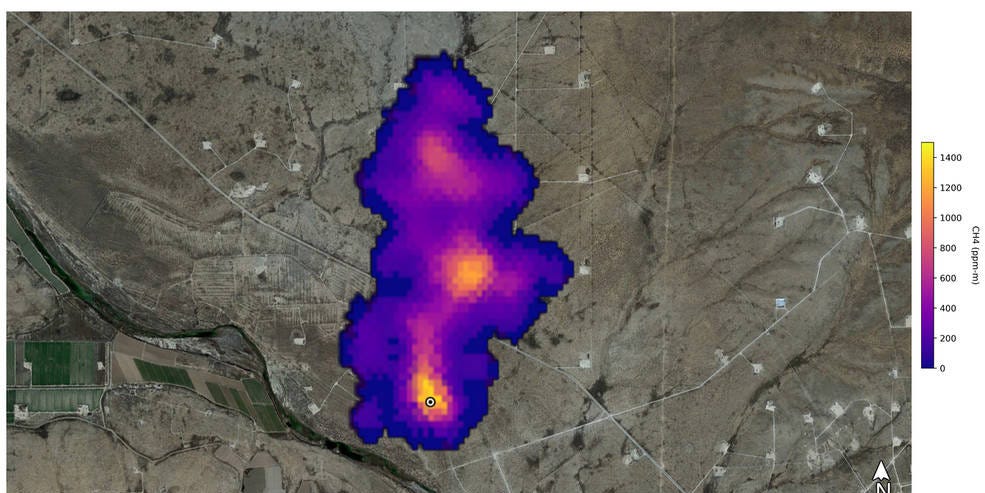
A NASA instrument sent into orbit to study desert dust ended up catching something far less innocent: enormous methane plumes pouring from industrial facilities and landfills. It is the scientific equivalent of buying a camera to photograph landscapes and accidentally recording a bank robbery in the background.
NASA’s Earth Surface Mineral Dust Source Investigation, better known as EMIT, identified more than 50 methane “super-emitters” during its first months aboard the International Space Station. The sources appeared across Central Asia, the Middle East, and the Southwestern United States. Some had been detected before, while others were newly revealed by the instrument’s sharp orbital vision.
The discovery was more than a spectacular collection of colorful methane maps. By locating individual sources with remarkable precision, EMIT showed how space-based monitoring could help governments, scientists, and facility operators find major leaks and respond before additional greenhouse gas escapes into the atmosphere.
What Is NASA’s EMIT Instrument?
EMIT stands for Earth Surface Mineral Dust Source Investigation. NASA developed the instrument at the Jet Propulsion Laboratory in Southern California and launched it aboard a SpaceX Dragon cargo spacecraft on July 14, 2022. It was subsequently installed on the exterior of the International Space Station.
Its primary mission was not to hunt for methane. EMIT was designed to map the mineral composition of dust-producing regions in Africa, Asia, Australia, and the Americas. That information helps climate scientists determine whether airborne mineral dust generally warms or cools the planet.
Bright minerals can reflect sunlight, while darker materials may absorb heat. Dust can also affect clouds, snowmelt, ecosystems, air quality, and the delivery of nutrients across continents. A cloud leaving the Sahara, for example, can travel thousands of miles and influence environments far beyond the desert where it began.
To study those minerals, EMIT uses an advanced imaging spectrometer. Instead of taking a conventional photograph, it separates reflected sunlight into hundreds of wavelengths. The resulting data reveal distinctive spectral patterns associated with particular materials and gases.
A Climate Detective With an Unexpected Side Job
Methane absorbs infrared radiation at specific wavelengths, producing a recognizable spectral fingerprint. EMIT can detect that fingerprint when a sufficiently concentrated plume lies between the ground and the instrument.
The instrument scans wide strips of Earth while resolving features roughly the size of a soccer field. That combination is important. A sensor with broad coverage may reveal a regional methane hotspot but struggle to identify the responsible equipment. A very detailed sensor may find individual leaks but examine only a limited area. EMIT brings useful coverage and facility-scale detail together.
The International Space Station’s orbit also allows it to pass over many inhabited and industrial regions between approximately 51.6 degrees north and south latitude. EMIT cannot observe every location every day, but it can investigate areas that are difficult, expensive, or politically complicated to survey from the ground.
What Are Methane Super-Emitters?
A methane super-emitter is a source that releases the gas at an unusually high rate. The term may describe malfunctioning oil and gas equipment, pipelines, storage facilities, coal operations, agricultural infrastructure, wastewater systems, or landfills.
There is no single universal threshold used in every scientific or regulatory context. The essential idea is that a relatively small number of sources can contribute a disproportionately large share of measured emissions. In other words, the methane problem does not always arrive as millions of equally tiny leaks. Sometimes it arrives through a few industrial fire hoses that nobody can see with ordinary eyes.
Some releases are persistent. Others occur intermittently because of equipment failures, maintenance, venting, pressure changes, or operational practices. This variability is one reason inventories based only on estimated emissions can miss significant events.
Why Methane Deserves Immediate Attention
Methane is the principal component of natural gas and the second-most important human-influenced greenhouse gas after carbon dioxide. Major human-related sources include oil and gas systems, livestock, landfills, coal mining, wastewater treatment, and rice cultivation.
Ton for ton, methane traps roughly 80 times more heat than carbon dioxide during the first 20 years after its release. Over a 100-year period, its warming influence remains more than 28 times greater. Atmospheric methane concentrations have more than doubled since preindustrial times, largely because of human activity.
There is, however, a sliver of encouraging news. Methane typically remains in the atmosphere for about a decade, far less time than carbon dioxide. Cutting emissions can therefore slow near-term warming relatively quickly. Carbon dioxide is the marathon problem; methane is the climate sprint happening while everyone is still tying their shoes.
The More Than 50 Methane Super-Emitters Found by EMIT
NASA announced the initial findings on October 25, 2022. In data collected after EMIT’s installation that July, researchers identified more than 50 high-emitting sources in Central Asia, the Middle East, and the Southwestern United States.
The early results included some of the largest methane plumes ever observed from space. Three examples demonstrated both the scale of the releases and the variety of infrastructure responsible for them.
Carlsbad, New Mexico: A Giant Permian Basin Plume
Southeast of Carlsbad, New Mexico, EMIT detected a methane plume approximately 2 miles, or 3.3 kilometers, long. The source was located in the Permian Basin, one of the world’s most productive oil and natural gas regions.
Scientists estimated that the site was emitting about 18,300 kilograms of methane per hour. That is roughly 40,300 pounds every hour from one observed source. The measurement illustrated why finding individual super-emitters can matter more than simply calculating a broad regional average.
Previous airborne research in the Permian Basin had already shown that a limited number of persistent, high-emitting sites could account for a substantial portion of observed methane pollution. Common causes can include faulty valves, malfunctioning flares, open hatches, leaking tanks, and other equipment problems.
Turkmenistan: Twelve Plumes Stretching for Miles
East of Hazar, a port city on Turkmenistan’s Caspian Sea coast, EMIT recorded 12 methane plumes associated with oil and gas infrastructure. Winds carried some of them more than 20 miles, or 32 kilometers, toward the west.
The combined estimated emission rate was approximately 50,400 kilograms per hour. NASA compared that total with the peak flow from the 2015 Aliso Canyon gas leak near Los Angeles, one of the largest accidental methane releases in U.S. history.
The comparison gave an abstract satellite measurement a rather uncomfortable sense of scale. Instead of one notorious disaster receiving international attention, multiple large plumes were appearing together over an industrial region.
Tehran, Iran: Methane Rising From Waste
South of Tehran, Iran, EMIT detected a plume at least 3 miles, or 4.8 kilometers, long coming from a major waste-processing complex. Researchers estimated its methane flow at about 8,500 kilograms per hour.
Landfills generate methane when organic material decomposes without oxygen. Food scraps, paper, wood, and yard waste may look harmless in a garbage pile, but buried together they can create a substantial greenhouse gas source.
Well-operated landfill gas systems can capture methane and burn it or use it to produce energy. Poor collection coverage, damaged wells, cracked covers, and other operational problems can allow large quantities to escape.
How EMIT Turns Light Into a Methane Map
EMIT does not photograph methane as a visible purple or orange cloud. Those colors are added to scientific visualizations so people can see the plume’s location and relative concentration.
The actual process begins with sunlight. Solar energy passes through the atmosphere, strikes Earth’s surface, and reflects toward the space station. Methane molecules absorb portions of that light at characteristic shortwave-infrared wavelengths.
EMIT records a spectrum for each observed area. Computer algorithms compare the data with methane’s known absorption pattern and estimate how much additional gas is present above normal background levels. When those enhancements form a coherent shape moving downwind from infrastructure, researchers can map a plume.
Scientists then combine the methane enhancement with information about wind speed and direction to estimate the emission rate. Wind data are crucial: the same quantity of gas looks more concentrated on a calm day than when strong winds spread it over a wider area.
What Satellite Measurements Can and Cannot Tell Us
Satellite detection is powerful, but it is not magical climate X-ray vision. Clouds can block the surface, while water vapor, bright terrain, aerosols, and unfavorable lighting can complicate retrievals. EMIT is most effective for large point sources rather than every small leak.
A single overpass also provides a snapshot, not a complete operating history. A plume detected on Tuesday might disappear after a valve is repaired, or an intermittent release might be absent when the space station passes overhead.
For those reasons, the strongest monitoring systems combine satellites with aircraft, drones, continuous sensors, facility records, and ground inspections. Space-based observations are excellent for finding suspicious locations. On-site teams remain essential for confirming the precise component, determining the cause, and repairing it.
Why Finding Super-Emitters Can Produce Fast Climate Benefits
The practical value of EMIT lies in attribution. A regional methane increase tells scientists that a problem exists. A plume pointing toward a particular landfill, compressor station, pipeline, or storage tank tells someone where to send a repair crew.
Many oil and gas emissions represent lost product. Capturing methane can reduce climate pollution while preserving fuel that would otherwise vanish into the atmosphere. Possible remedies include tightening valves, replacing seals, fixing vapor-recovery systems, improving flare performance, and changing venting practices.
Landfills may require expanded gas-collection wells, better surface covers, repaired piping, or improved monitoring. Agricultural operations can reduce releases through manure-management systems, feed strategies, and methane capture where technically appropriate.
Not every super-emitter will be cheap or easy to eliminate. Some sources reflect routine operating practices or aging infrastructure rather than one broken bolt waiting for a wrench. Nevertheless, the concentration of emissions among high-rate sources creates an opportunity to achieve meaningful reductions by prioritizing the worst offenders.
Open Data Adds Accountability
NASA makes EMIT products available to researchers and the public through its Earth science data systems and an open methane-data portal. Public access allows universities, regulators, nonprofit organizations, journalists, and facility operators to examine detections independently.
This transparency can improve emissions inventories, guide field campaigns, and encourage faster responses. It also changes the basic politics of invisible pollution. A major release is more difficult to dismiss when its location, shape, and estimated scale can be mapped from orbit.
Remote sensing is increasingly influencing U.S. methane policy as regulators explore ways to incorporate approved satellite and airborne observations into super-emitter notification programs. The broader goal is to connect detection with action rather than create a beautiful global atlas of leaks that everyone admires and nobody repairs.
EMIT Is Part of a Larger Methane-Tracking Network
No single instrument can provide continuous, high-resolution coverage of the entire planet. The future of methane monitoring therefore depends on complementary systems operating at different scales.
Broad-area satellites can identify regional hotspots. High-resolution orbital instruments can locate individual plumes. Aircraft and drones can investigate facilities in greater detail, while ground sensors can watch continuously and detect short-lived events between overpasses.
EMIT’s success also highlights the value of imaging spectroscopy. An instrument originally built to identify surface minerals demonstrated that the same spectral information could expose concentrated methane and carbon dioxide emissions. That unexpected versatility has helped accelerate interest in missions designed specifically to map greenhouse gas point sources.
As the number of observing platforms grows, the central challenge will shift from merely finding emissions to validating measurements, notifying responsible parties, documenting repairs, and confirming that the pollution has stopped.
Experiences and Practical Lessons From Tracking Methane From Space
The most revealing experience associated with EMIT is not simply seeing a dramatic colored plume. It is following the chain of evidence from an orbital measurement to a real facility on the ground. That process teaches several practical lessons about environmental monitoring.
Experience One: Explore the Data Like a Detective
For a researcher or curious reader opening an EMIT methane map, the first impression is often visual. A narrow plume may begin at a small point, widen with distance, and bend in the direction of the wind. Roads, industrial structures, wells, or landfill boundaries provide geographic context.
The sensible approach is to resist jumping immediately from “plume near facility” to “case closed.” Investigators compare the plume’s origin with infrastructure maps, weather data, earlier observations, and other sensors. They also check for clouds, unusual surface reflectance, and neighboring sources.
This experience demonstrates how modern climate science works: not through one dazzling image, but through several independent pieces of evidence fitting together. The satellite provides a strong lead. Verification turns that lead into an actionable finding.
Experience Two: Repeated Observations Change the Story
Imagine that EMIT detects a large release during one pass but finds nothing during the next suitable observation. The source may have been repaired, shut down, or intermittent. Now imagine that the plume appears repeatedly in nearly the same place. That persistence makes the source a higher priority for investigation and mitigation.
Repeated measurements help separate temporary events from chronic problems. They can also test whether a repair actually worked. A company may report that equipment was fixed, but a later plume offers a blunt second opinion from several hundred miles above Earth.
This is why satellite data should be viewed as a sequence rather than a collection of isolated pictures. Each observation adds another frame to the facility’s emissions history.
Experience Three: The Biggest Number Is Not the Only Priority
A massive emission rate naturally attracts attention, but experienced investigators consider more than size. They examine how long the release continues, whether it is technically fixable, how frequently the source operates, and whether nearby communities face additional air-quality or safety concerns.
A somewhat smaller but persistent plume may release more methane over a year than a spectacular event lasting a few hours. Likewise, a moderate leak that can be repaired tomorrow may offer a faster climate benefit than a larger source requiring years of infrastructure changes.
The best response combines scale, duration, confidence, repair feasibility, and environmental context. This prevents methane monitoring from becoming a contest in which only the most photogenic plume receives attention.
Experience Four: Better Visibility Can Improve Behavior
When large releases were difficult to observe, operators and regulators often depended heavily on self-reported estimates or occasional inspections. Orbital measurements introduce a new experience: independent observation across borders and remote terrain.
That visibility can encourage preventive maintenance because a large leak may no longer remain hidden for long. It can also help responsible operators demonstrate progress by showing that a previously detected plume disappeared after repairs.
The lesson from EMIT is ultimately practical and hopeful. Methane is invisible, but its emissions do not have to remain unknowable. Once a super-emitter is located and quantified, the discussion can move from vague concern to specific questions: What equipment failed? Who can fix it? How quickly can the release be stopped? And did the repair last?
Conclusion
NASA’s discovery of more than 50 methane super-emitters showed how rapidly space-based imaging spectroscopy can transform an invisible climate problem into a map of identifiable sources. EMIT found enormous plumes over oil and gas infrastructure in New Mexico and Turkmenistan, as well as a major waste facility near Tehran.
The instrument cannot detect every leak or replace field inspections. What it can do is reveal high-impact targets across wide areas, direct attention toward facilities that deserve investigation, and support verification after repairs.
Methane reduction is one of the clearest opportunities to slow warming in the near term. With better satellites, open data, repeated observations, and crews ready to act on the findings, humanity may finally give major emitters something they have rarely encountered: nowhere to hide.
Note: The “more than 50” figure refers to EMIT’s initial methane super-emitter findings announced by NASA in October 2022. Plume lengths and hourly emission rates are rounded scientific estimates and may vary with atmospheric conditions and subsequent analysis.